Johnson County Exec Airport (OJC / KOJC) — Olathe, KS
Johnson County Exec Airport (OJC)
OJC
Johnson County Exec Airport (OJC)
Olathe, KS
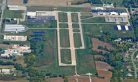
Latest photo of Johnson County Exec Airport (OJC)
Red Harrell
Johnson County Exec Airport (OJC/KOJC) is a public-use airport located in Olathe, KS. The airport sits at an elevation of 1096 feet above mean sea level. It features 1 runway. Aviation communications are supported by 14 published radio frequencies. The gallery includes 1 photo of operations and aircraft at the airport.
| FAA Information Effective | 2026-09-03 |
| Airport Identifier | OJC |
| Airport Status | Operational |
| Longitude/Latitude |
94°44'15.3020"
W /
38°50'51.3520"
N -94.737584 / 38.847598 (Estimated) |
| Elevation | 1096.30 ft / 334.15 m (Surveyed) |
| Land | 568 acres |
| From nearest city | 4 nautical miles SE of Olathe, KS |
| Location | Johnson County, KS |
| Magnetic Variation | 04E (2000) |
| Airport Use | Open to public |
| Wind indicator | Yes |
| Segmented Circle | No |
| Control Tower | ATCT |
| Lighting Schedule | SEE RMK |
| Beacon Color | White-Green (lighted land airport) |
| Landing fee charge | No |
| Sectional chart | KANSAS CITY |
| Region | ACE - Central |
| Traffic Pattern Alt | 1000 ft |
| Responsible ARTCC | ZKC - KANSAS CITY |
| Tie-in FSS | COU - COLUMBIA |
| FSS on Airport | No |
| FSS Toll Free | 1-800-WX-BRIEF |
| NOTAMs Facility | OJC (NOTAM-d service available) |
Runway 18/36
| Dimensions | 4097 x 75 ft (1249 x 23 m) |
| Surface | CONC (EXCELLENT) |
| Surface treatment | |
| Edge lights | Medium |
| 18 | 36 | |
|---|---|---|
| Alignment | 180° | ° |
| Physical elevation | 1096.30 ft | 1050.20 ft |
| Coordinates | 38.853222 / -94.737568 | 38.841974 / -94.737600 |
| Traffic pattern | Left | Left |
| Runway marking | Non-precision instrument , Good Condition | Non-precision instrument , Good Condition |
| ILS type | LOC/DME | LOCALIZER |
| VGSI | 4-light PAPI on right | 2-box on left |
| Approach light | MALSR | |
| Runway end lights | No |
- UPON TAKEOFF FOR RYS 18 & 36 MAINTAIN RY HEADING UNTIL PASSING 1,600 FT MSL.
- BIRDS, WATERFOWL, WILDLIFE ON & INVOF ARPT.
- TO CONFIRM SNOW REMOVAL AND WINTER CONDITIONS NOV-APR CALL 913-715-6005.
- FOR CD WHEN ATCT IS CLSD CTC MCI APCH AT 816-329-2710.
- IT IS ADVISED THAT ROTOCRAFT AVOID THE OVERFLIGHTS OF SURROUNDING NEIGHBORHOODS.
- HEL CONDS: PROVDD APCH/DEP PATHS TO LNDG AREA MAINTD FOR MIN 8:1 GLIDE SLOPE & TRSNL SFC BE MAINTD FOR 2:1 SLOPE.