Log in
New user?
Sign up for free
Tell a Friend
Home
Airport
USA Airports
Search USA Airports
World Airports
Search World Airports
Upload Airport Photo
Random Airport Photos
Recent Airport Photos
Aircraft
Search Aircraft & Photo
Browse by Manufacturer
Add New Aircraft
Upload Aircraft Photo
Random Aircraft Photos
Recent Aircraft Photos
Photographers
Slideshows
Articles
Forums
Member Section
API
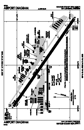
San Luis County Regional Airport (SBP) Maps
San Luis Obispo, CA
All Airports in California
All Airports in United States
Home
FAA Information
Maps
Statistics
Nearby Airports
Hotels
Weather
Photos
Aircraft Photos
SBP
Airport Map
Airport Diagram
Download SBP Airport Diagram (PDF) from FAA
Back to home