Jesse Viertel Meml Airport (VER / KVER) — Boonville, MO
Jesse Viertel Meml Airport (VER)
VER
Jesse Viertel Meml Airport (VER)
Boonville, MO
Latest photo of Jesse Viertel Meml Airport (VER)
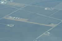
Mark Pasqualino
Jesse Viertel Meml Airport (VER/KVER) is a public-use airport located in Boonville, MO. The airport sits at an elevation of 715 feet above mean sea level. It features 1 runway. Aviation communications are supported by 4 published radio frequencies. The gallery includes 1 photo of operations and aircraft at the airport.
| FAA Information Effective | 2026-09-03 |
| Airport Identifier | VER |
| Airport Status | Operational |
| Longitude/Latitude |
92°40'57.6000"
W /
38°56'48.2000"
N -92.682667 / 38.946722 (Estimated) |
| Elevation | 715.00 ft / 217.93 m (Surveyed) |
| Land | 197 acres |
| From nearest city | 3 nautical miles SE of Boonville, MO |
| Location | Cooper County, MO |
| Magnetic Variation | 02E (2000) |
| Airport Use | Open to public |
| Wind indicator | Yes |
| Segmented Circle | Yes |
| Control Tower | NON-ATCT |
| Lighting Schedule | SEE RMK |
| Beacon Color | White-Green (lighted land airport) |
| Landing fee charge | No |
| Sectional chart | KANSAS CITY |
| Region | ACE - Central |
| Traffic Pattern Alt | 785 ft |
| Responsible ARTCC | ZKC - KANSAS CITY |
| Tie-in FSS | COU - COLUMBIA |
| FSS on Airport | No |
| FSS Toll Free | 1-800-WX-BRIEF |
| NOTAMs Facility | COU (NOTAM-d service available) |
Runway 18/36
| Dimensions | 4000 x 75 ft (1219 x 23 m) |
| Surface | CONC (EXCELLENT) |
| Surface treatment | |
| Edge lights | Medium |
| 18 | 36 | |
|---|---|---|
| Alignment | 185° | 5° |
| Physical elevation | 708.70 ft | 711.90 ft |
| Coordinates | 38.952200 / -92.682098 | 38.941257 / -92.683241 |
| Traffic pattern | Left | Left |
| Runway marking | Non-precision instrument , Good Condition | Non-precision instrument , Good Condition |
| VGSI | 4-light PAPI on left | 4-light PAPI on left |
| Runway end lights | Yes | Yes |
- EXTSV STUDENT PILOT TRNG INVOF ARPT.
- NOISE ABATEMENT, FOR RY 36 FLY RY CNTRLN TO 1,500 FT BEFORE TURNING ON CRS.
- RY 18 CALM WIND RY.
- INTENSIVE AERIAL CROP-DUSTING ACTIVITY APRIL-OCTOBER
- FOR CD CTC MIZZOU APCH AT 417-868-5620/5619.
- PROVIDED AIRCRAFT IN THE TIE-DOWN AREA ARE PARKED WITH THE TAILS TOWARD THE WEST TO AVOID PENETRATION OF THE TRANSITIONAL SURFACE.